Tutorial: Implementing A Point-Cloud Processing Pipeline
LiGuard is designed to help researchers build dynamic point-cloud
processing pipelines. It act as an execution engine for I/O, processing,
and visualization of both point-cloud and image data. A high-level
architecture diagram is given here.
Let’s see how to use LiGuard with a simple yet intuitive example.
An Example Pipeline
In this example, we will implement a simple pipeline to read (a subset of) KITTI dataset, crop the point-clouds, remove any labels that are out of the crop-bound, also remove labels that have less than 1000 points, and save the processed dataset in OpenPCDet annotation standard. Let’s break down the pipeline into steps:
# Pipeline
1. Read: Read KITTI dataset.
2. Process:
- Crop: Crop the point-clouds.
- Filter Operation 1: Remove out-of-bound labels.
- Filter Operation 2: Remove labels with less than 1000 points (in the 3d bounding-box).
3. Post-Process:
- Save: Cropped point-clouds in npy format.
- Save: Labels in OpenPCDet annotation standard.
Implementing the Pipeline in LiGuard
In LiGuard, a pipeline is implemented by creating a configuration
YAML (.yml) file. A default template pipeline configuration (.yml) file
config_template.yml is provided in the configs directory. Please
do not delete or modify this file. Instead, duplicate it and rename to
your pipeline name; for this example, let’s name it
my_kitti_config.yml.
Understanding the Pipeline Config File
This is how it looks:
# This is a LiGuard pipeline configuration file.

data: # dataset configurations
    path: 'data' # root directory containing dataset
    lidar_subdir: 'lidar' # subdirectory containing point clouds
    camera_subdir: 'camera' # subdirectory containing images
    label_subdir: 'label' # subdirectory containing labels
    calib_subdir: 'calib' # subdirectory containing calibration files
    size: 10 # number of frames to annotate

    lidar:
        enabled: True # set True to read point clouds from disk
        pcd_type: '.bin' # can be .bin or .npy
    camera:
        enabled: False # set True to read images from disk
        img_type: '.png' # most image types are supported
    calib:
        enabled: True # set True to read calibration files from disk
        clb_type: 'kitti' # can be kitti or sustechpoints
    label:
        enabled: False # set True to read labels from disk
        lbl_type: 'kitti' # can be kitti, openpcdet, or sustechpoints

sensors: # lidar and camera configurations
    lidar: # lidar sensor configurations, at this point only Ouster lidars are supported, support for other lidars is coming soon
        enabled: False # set True to stream point clouds from sensor, please set False if reading from disk
        hostname: '192.168.1.2' # sensor ip address or hostname
        manufacturer: 'Ouster' # sensor manufacturer
        model: 'OS1-64' # sensor model
        serial_number: '000000000000' # sensor serial number
    camera: # camera sensor configurations, at this point only Flir cameras are supported, support for other cameras is coming soon
        enabled: False # set True to stream point clouds from sensor, please set False if reading from disk
        hostname: '192.168.1.3' # sensor ip address or hostname
        manufacturer: 'Flir' # sensor manufacturer
        model: 'BFS-PGE-16S2C-CS' # sensor model
        serial_number: '00000000' # sensor serial number
        camera_matrix: [2552.449042506032, 0.0, 766.5504021841039, 0.0, 2554.320087252825, 553.0299764355634, 0.0, 0.0, 1.0] # camera matrix (K)
        distortion_coeffs: [-0.368698, 0.042837, -0.002189, -0.000758, 0.000000] # distortion coefficients (D)
        T_lidar_camera: [[-0.00315, 0.00319, 0.99999, -0.17392], [-0.99985, -0.01715, -0.00309, 0.00474], [0.01714, -0.99985, 0.00324, -0.05174], [0.00000, 0.00000, 0.00000, 1.00000]] # 4x4 transformation matrix from camera to lidar

proc: # liguard processing configurations
    pre:
        dummy: # dummy pre-process
            enabled: False # set True to enable
            priority: 1 # priority of process - lower is higher
    lidar:
        crop:
            priority: 1 # priority of process - lower is higher
            enabled: False # set True to crop point cloud
            min_xyz: [-40.0, -40.0, -4.0] # minimum x, y, z
            max_xyz: [+40.0, +40.0, +2.0] # maximum x, y, z
        project_image_pixel_colors:
            enabled: False # set True to paint point cloud with rgb
            priority: 2 # priority of process - lower is higher
    camera:
        project_point_cloud_points: # project point cloud points to camera image
            enabled: False # set True to project point cloud points to camera image
            priority: 1 # priority of process - lower is higher
    calib:
        dummy: # dummy calibration process
            enabled: False # set True to enable
            priority: 1 # priority of process - lower is higher
    label:
        remove_out_of_bound_labels: # crop out of bound bboxes
            enabled: False # set True to crop labels
            priority: 1 # priority of process - lower is higher
    post:
        create_per_object_pcdet_dataset: # create per object dataset in pcdet format
            enabled: False # set True to enable
            priority: 1 # priority of process - lower is higher
        create_pcdet_dataset: # create dataset in pcdet format
            enabled: False # set True to enable
            priority: 1 # priority of process - lower is higher

visualization: # visualization parameters
    enabled: True # set True to visualize
    lidar:
        space_color: [0, 0, 0] # color of background space
        bound_color: [0, 0, 1] # point cloud range bound bbox color
        point_size: 2.0 # rendered point size
    camera:
        bbox_line_width: 2 # bbox line width

logging: # parameters for logger
    level: 0 # log level can be 0 (DEBUG), 1 (INFO), 2 (WARNING), 3 (ERROR), 4 (CRITICAL
    path: 'logs' # path to save logs

threads: # don't change unless debugging
    io_sleep: 0.01 # input/output threads sleep time in seconds
    proc_sleep: 0.01 # processing threads sleep time in seconds
    vis_sleep: 0.01 # visualization threads sleep time in seconds
You can see that the pipeline config file is divided into six main sections. It is important to understand the structure of the pipeline config file to build the pipeline. Here is a brief overview of each section:
data: to configure dataset paths and types.
sensors: to configure sensor connection paramters in case of streaming data.
proc: to configure processing steps, it has:
- pre: for configuring pre-processing tasks
- lidar: for configuring point-cloud processing
- camera: for configuring image processing
- calib: for configuring calibration data processing
- label: for configuring label/annotation processing
- and post sections: for configuring post-processing tasks
visualization: for setting visualization parameters.
logging: for setting logging level and path.
threads: responsible for changing threading paramters. # don't change unless debugging
Please note that you must not delete the main sections (all the section
names given above are main sections); so if you were to assign levels
based on indenting, upto level 2 sections must be kept same (unless you
are contributing to the repo and think to add a feature to framework
itself). However, you can add new sections (at level 3 or more), so for
example, you can add a new section under proc/lidar/ but not under
proc.
Implementing the Pipeline Steps
Let’s now modify my_kitti_config.yml to implement the pipeline we
devised above. LiGuard has many built-in utility
processes/functions; a list of those is provided in Utility
Functions that can be used to build
the pipeline. We’ll be using some of these utility functions in our
example.
Pipeline Step # 1: LiGuard provides built-in capability to read many
standard datasets including KITTI, OpenPCDet, and SUSTechPoints (support
for more public datasets is coming soon). Nothing needs to be done for
this step, as it is already configured in the template pipeline config
file.
Pipeline Step # 2: - Crop: a built-in utility process crop under
algo/lidar.py can be used to crop the point-clouds. - Filter
Operation 1: a utility process remove_out_of_bound_labels under
algo/label.py can be used.
Adding a New Process in the Pipeline
However, as you can see in the pipeline config file, there is no
built-in utility processes for Filter Operation 2 in our pipeline. This
provides an opportunity to demonstrate how to add a novel process in the
pipeline. Please follow the steps below to add a new process in the
pipeline: - add following lines under proc/label/ section in
my_kitti_config.yml:
remove_less_point_labels: # remove labels with less than min_points points
    enabled: False # set True to remove labels
    priority: 2 # priority of process - lower is higher
    min_points: 1000 # minimum number of point-cloud points that must be inside the 3d bounding-box label to be consider a label valid otherwise it will be removed
Every process function in the pipeline config file must follow the following standard format:
# config.yml
...
proc:
    category: # category can be pre, lidar, camera, calib, label, or post
        process_name: # must be at level 3
            enabled: boolean
            priority: integer
            # add more parameters as per your requirement
...
enabled: a boolean to enable/disable the process. -
priority: an integer to set the priority of the process in the
category, for example, in the label category, the
remove_out_of_bound_labels process has a priority of 1, so we set
the remove_less_point_labels priority to 2; this means that the
remove_out_of_bound_labels process will be executed before the
remove_less_point_labels process.You can also add more parameters as per your requirement. For example in
this case, we added min_points (to make this a tunable paramter in
the GUI later) to set the minimum number of points that must be inside
the 3d bounding-box label to be consider a label valid otherwise it will
be removed. - add the following function in algo/label.py:
def remove_less_point_labels(data_dict: dict, cfg_dict: dict):
    # Get logger object from data_dict
    if 'logger' in data_dict: logger:Logger = data_dict['logger']
    else: print('[CRITICAL ERROR]: No logger object in data_dict. It is abnormal behavior as logger object is created by default. Please check if some script is removing the logger key in data_dict.'); return

    # Check if required data is present in data_dict
    if "current_label_list" not in data_dict:
        logger.log('[algo->label.py->remove_less_point_labels]: current_label_list not found in data_dict', Logger.ERROR)
        return
    if 'current_point_cloud_numpy' not in data_dict:
        logger.log('[algo->label.py->remove_less_point_labels]: current_point_cloud_numpy not found in data_dict', Logger.ERROR)
        return

    # Get label list and point cloud
    lbl_list = data_dict['current_label_list']
    point_cloud = data_dict['current_point_cloud_numpy']

    output = []

    for lbl_dict in lbl_list:
        if 'lidar_bbox' not in lbl_dict: continue
        # Get bounding box center, extent, and euler angles
        bbox_center = lbl_dict['lidar_bbox']['lidar_xyz_center']
        bbox_extent = lbl_dict['lidar_bbox']['lidar_xyz_extent']
        bbox_euler_angles = lbl_dict['lidar_bbox']['lidar_xyz_euler_angles']
        R = o3d.geometry.OrientedBoundingBox.get_rotation_matrix_from_xyz(bbox_euler_angles)
        # Create an oriented bounding box
        try: rotated_bbox = o3d.geometry.OrientedBoundingBox(bbox_center, R, bbox_extent)
        except:
            logger.log(f'[algo->label.py->remove_less_point_labels]: failed to create an OrientedBoundingBox, skipping ...', Logger.WARNING)
            continue
        # Get the indices of points within the bounding box
        inside_points = rotated_bbox.get_point_indices_within_bounding_box(o3d.utility.Vector3dVector(point_cloud[:, 0:3]))
        # If the number of points within the bounding box is greater than the specified threshold, add the label to the output list
        if len(inside_points) >= cfg_dict['proc']['label']['remove_less_point_labels']['min_points']: output.append(lbl_dict)

    # Update the label list in data_dict
    data_dict['current_label_list'] = output
Remember that function name must match the name given in the pipeline config file otherwise it will not be executed.
Let’s take a look into the function. The function
remove_less_point_labels takes two arguments: data_dict and
cfg_dict that are automatically passed to it by framework as it
called (if enabled) in order of its priority. This is a standard
that LiGuard follows, so to create any process for your pipeline
your function must have the following signature:
# it must be written in algo/<category>.py file where <category> can be pre, lidar, camera, calib, label, or post
your_function_name(data_dict: dict, cfg_dict: dict)):
    ... # your function logic
Understanding Parameter Passing in LiGuard
Let’s talk a little bit more about the data_dict and cfg_dict as
these are automatically passed (by reference) to all processes in the
pipeline. The data_dict is a dictionary that, as the name suggests,
contains the data that is shared between different processes in the
pipeline. The data_dict contains the following keys: - logger: a
logger object that can be used to log messages. -
current_frame_index: an integer representing the current frame
index. - maxium_frame_index: an integer representing the maximum
frame index. and may contain follwoing keys depending on the pipeline. -
current_point_cloud_numpy: a numpy array containing the current
point cloud. - current_image_numpy: a numpy array containing the
current image. - current_calib_data: a dictionary containing the
current calibration data in KITTI calibration format, however this may
change based on unavailbility of all matrices. It may contain following
keys: - P2: a 3x4 projection matrix. - R0_rect: a 3x3
rectification matrix. - Tr_velo_to_cam: a 4x4 transformation matrix
from lidar to camera. - current_label_list: a list of dictionaries
containing the current labels. Each dictionary item in the list may
contain the following keys: - label_class: a string representing the
label class. - lidar_bbox: a dictionary containing the lidar
bounding box. It may contain the following keys: - lidar_xyz_center:
a list containing the x, y, z center of the bounding box. -
lidar_xyz_extent: a list containing the x, y, z extent of the
bounding box. - lidar_xyz_euler_angles: a list containing the x, y,
z euler angles of the bounding box. - camera_bbox: a dictionary
containing the camera bounding box. It may contain the following keys: -
camera_uv_center: a list containing the u, v center of the bounding
box. - camera_uv_extent: a list containing the u, v extent of the
bounding box. - camera_uv_euler_angles: a list containing the u, v
euler angles of the bounding box.
Please note that the above mentioned keys are standard keys that are
used accross the framework. However, you can add more keys to the
data_dict as per your requirement to be shared between different
components of the framework.
The cfg_dict mirros your pipeline config file, so you can access any
parameter from the pipeline config file using this dictionary. Each
level in the pipeline config file translates to a sub-dictionary in
cfg_dict.
Now let’s look into this function’s logic: - The function first checks
if the required data is present in the data_dict. If not, it logs an
error message and returns. It is always a good practice to check if the
required data is present in the data_dict before using it. - The
function then gets the label list and the point cloud from the
data_dict and for each label: - It creates an oriented bounding box
using the label’s center, extent, and euler angles, checks if the number
of points within the bounding box is greater than the specified
threshold, and if so, adds the label to the output list. - Finally, it
changes the current_label_list in the data_dict, it is important
to create/update the data in the data_dict so that it can be shared
across different processes in the pipeline.
Pipeline Step # 3: LiGuard provides built-in capability to save the
processed lidar data in npy format and labels in OpenPCDet annotation
standard. It is already configured in the pipeline config file, so you
don’t need to do anything.
Running the Pipeline
Now let’s run the pipeline, run the following command to start the
LiGuard:
python main.py
This will start the LiGuard and you’ll see the following two
windows:
Configuration Window |
Log Window |
|---|---|
|
|
On the left is the Configuration Window, it lets you open, save, and apply configurations. On the right is the ``Log`` window, it shows the logs that are generated during the pipeline execution by both the built-in functions and the user-defined functions (if user-defined functions are using the logger object).
Opening the Pipeline Config File
Please go ahead and click open, then select the my_kitti_config.yml
file and click open. This will load the pipeline config file into the
LiGuard. You can change the configuration parameters, in this
example case, enable all the data reading processes lidar,
camera, calib, and label and disable all the processes under
proc, click apply to apply the changes. You’ll see the data being
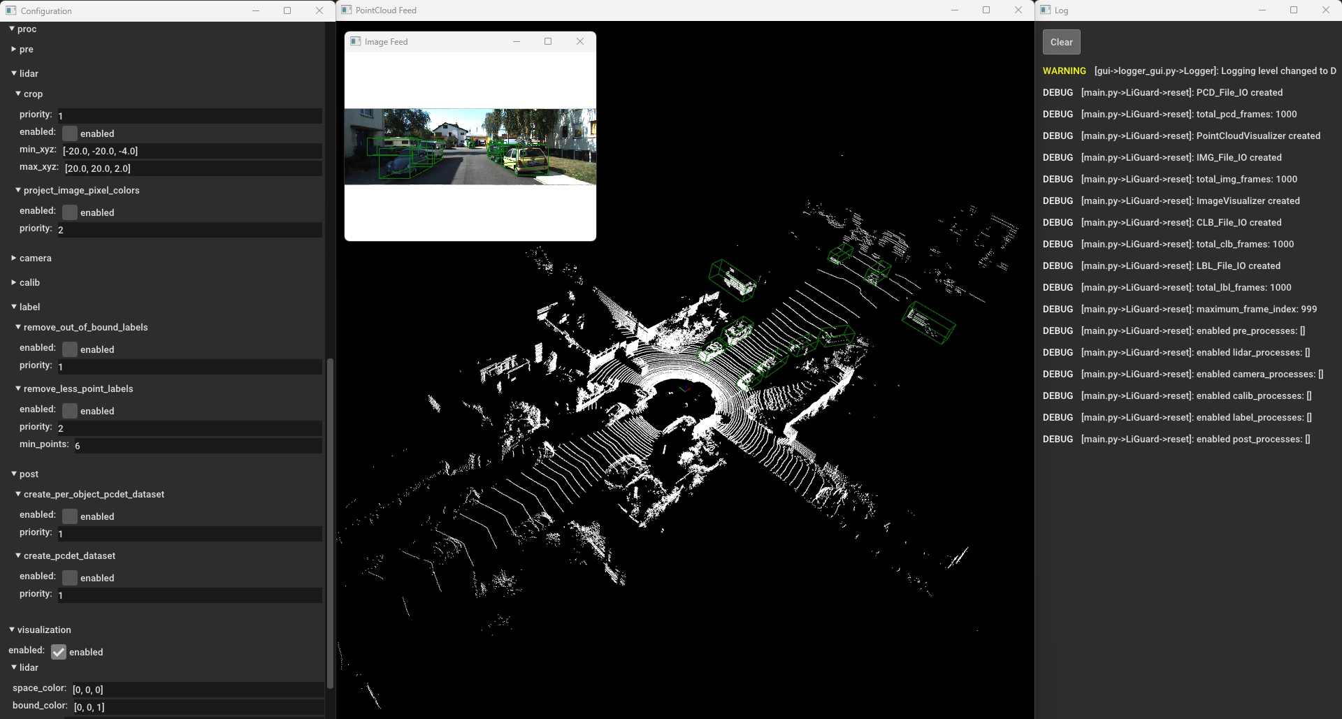
read from the disk and displayed in the visualization window.  LiGuard’s Layout: from left to right:
Configuration Window, Visualization Window, and Log Window. #####
Navigation You can navigate through the frames using the
 left arrow
and right arrow keys, or press the space bar to play the frames
in sequence.
Processing the Data
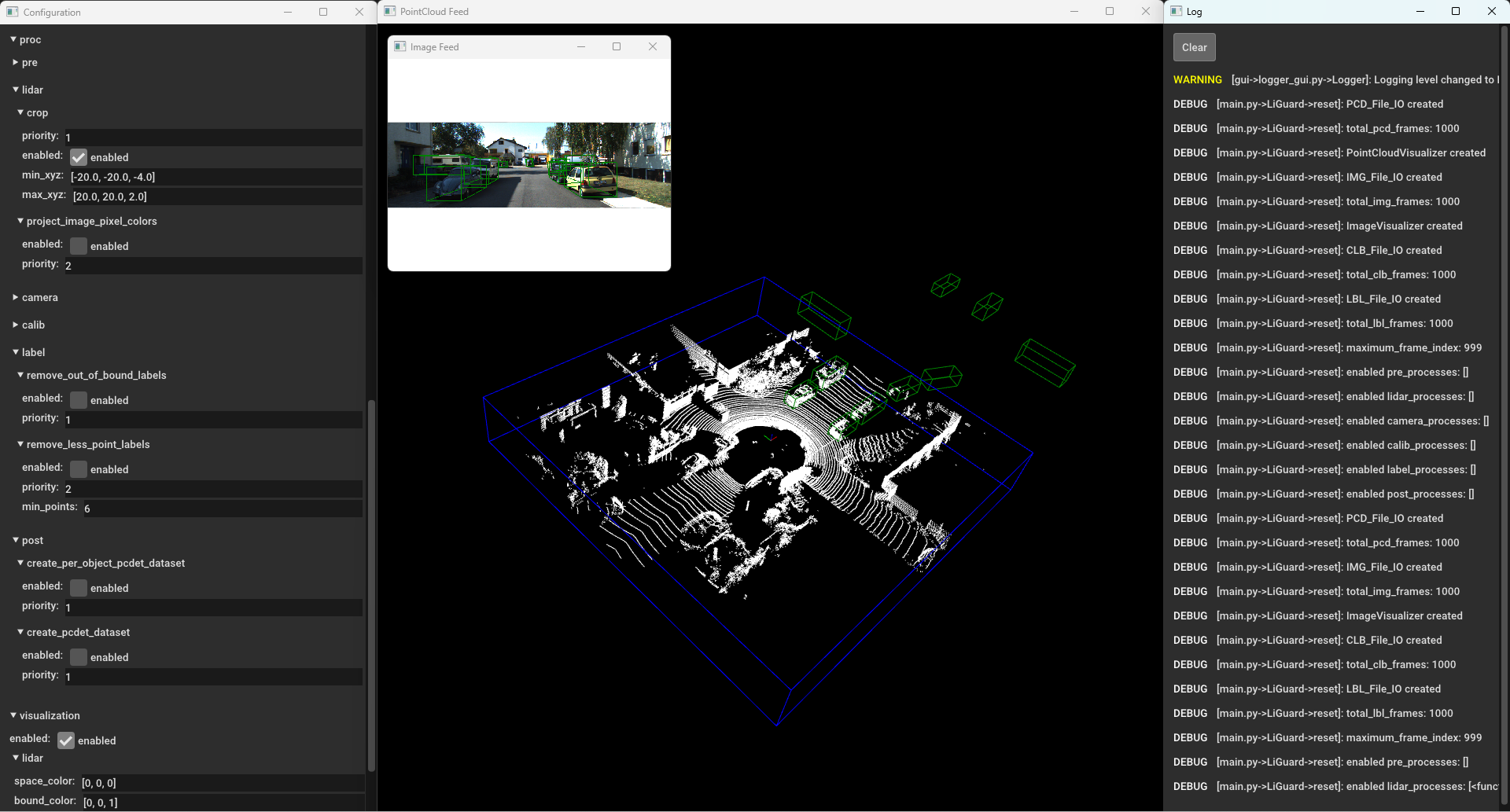
Please pause the frames by pressing the space bar again and then enable
the ’crop process under proc/lidar and click apply. You’ll see
the point-clouds being cropped.  LiGuard
in Action - Cropping Point-Cloud(s)
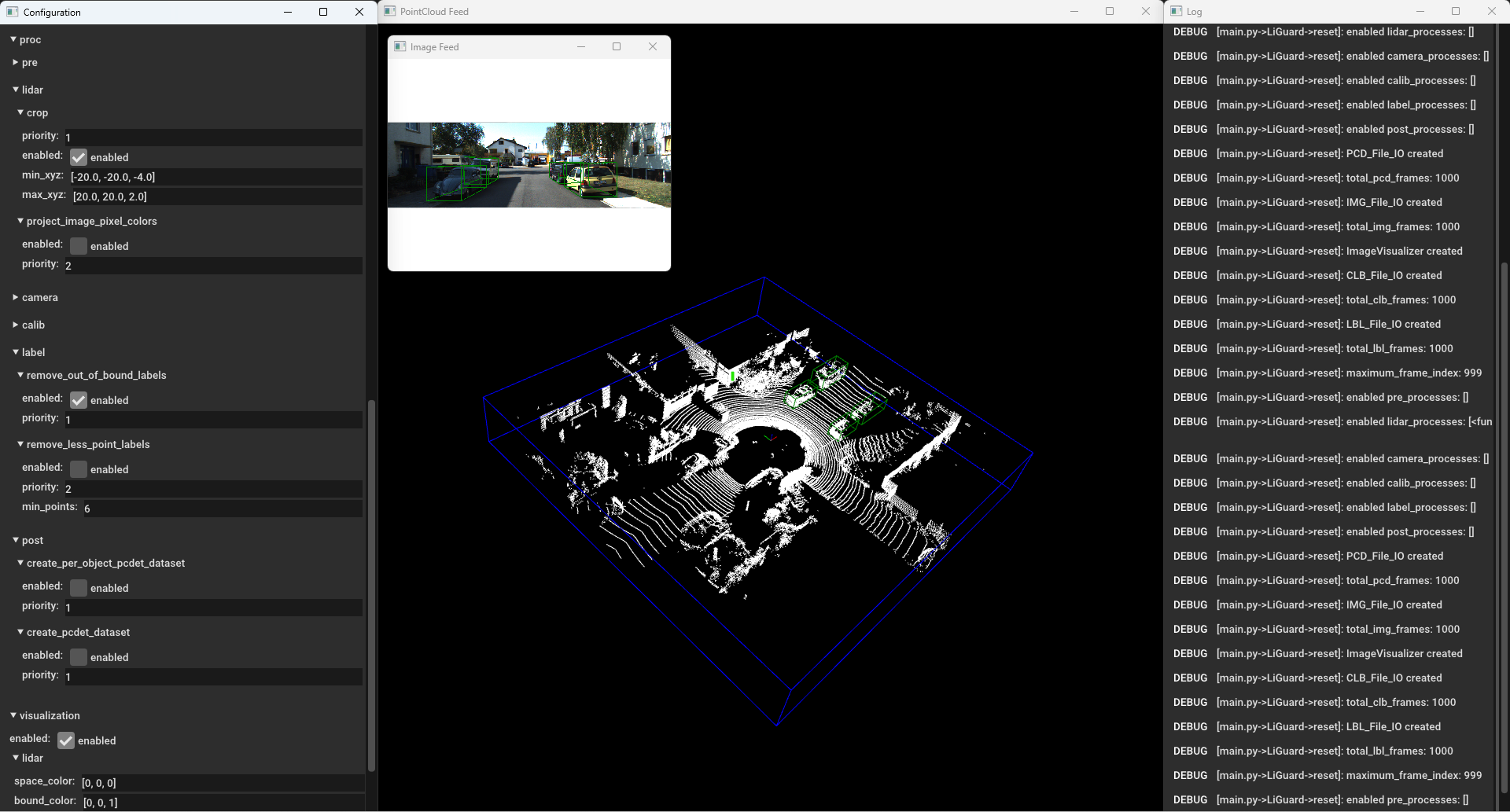
Similarly, enable the remove_out_of_bound_labels and see the
results.  Liguard in Action - Cropping + Filtering Out Out-of-Bound
Annotation
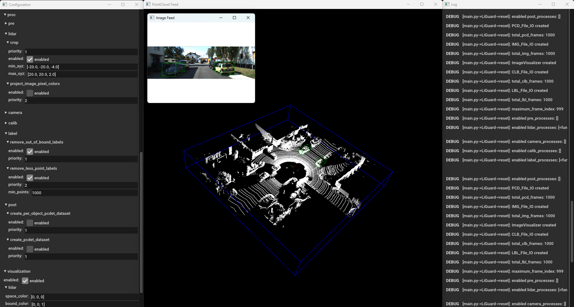
Moving on, please enable, remove_less_point_labels and see the
results.  Liguard in Action - Cropping + Filtering Out Out
Out-of-Bound and Annotations With < 1000 Points
Finally, if the pipeline is working as expected (check it by manually
navigating a few frames), you can save the pipeline config file by
clicking the save button. To process the entire dataset, you can
change the size parameter under the data section in the pipeline
config file to the number of frames you want to bulk process, disable
the visualization, enable the create_pcdet_dataset under
proc/post and click apply. Press the space bar to start the
processing. The Log window will show the progress of the processing.
The processed data is stored under in output directory under the
root directory of the dataset.
Verifying the Processed Data
You can verify the processed data by creating a new pipeline config file
and loading the processed data. For our example, please duplicate the
config_template.yml, rename it, and start LiGuard. In the
data section of configuration set the path and sub-paths, make sure

